
Case Study: Monitoring Deep-Sea Recovery with Autonomous Imaging
-
University of Rhode Island (URI)
-
Habitat Assessment and Evaluation (HAE) project as part of the Mesophotic and Deep Benthic Communities (MDBC) restoration portfolio, led by the National Oceanic and Atmospheric Administration (NOAA) and the Department of the Interior
-
Gulf of America
-
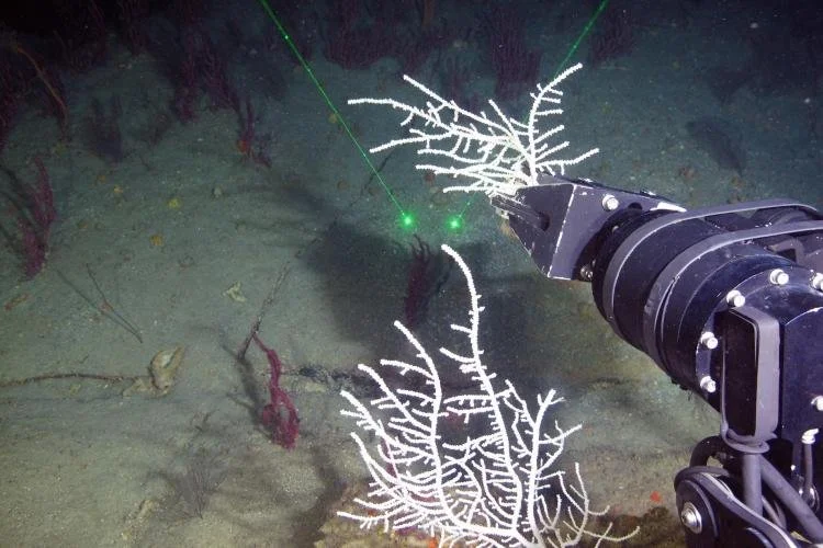
SubC Imaging Rayfin Autonomous Timelapse Camera System with optional Hibernate Mode, Aquorea LEDs, and MantaRay Parallel Laser
In 2010, the Deepwater Horizon disaster released millions of barrels of oil into the Gulf of America (formerly known as the Gulf of Mexico). While the impacts at the surface were highly visible, damage to deep benthic communities, including slow-growing coral and sponge habitats, remained largely hidden. Corals in these regions can live for more than a thousand years, making recovery a process measured in decades, not years.
The University of Rhode Island (URI) is partnering with the National Oceanic and Atmospheric Administration and the Department of the Interior to restore Mesophotic and Deep Benthic Communities (MDBC) injured by the oil spill. Through the Habitat Assessment and Evaluation (HAE) Project, partners are conducting work to better understand how deep benthic habitats respond to environmental variability over time, supporting long-term restoration decisions across the Gulf.
The Challenge: Capturing Reliable Long-Term Visual Data
One component of the project, led by Andrew J. Davies, professor in the College of the Environment and Life Sciences and the Graduate School of Oceanography at URI, and his team of scientists and students, addresses the need for continuous time-series data to better understand restoration potential. To support this work, they built large custom landers, each standing 7 feet tall and 7 feet wide and weighing approximately 2,500 pounds in air, equipped with a variety of oceanographic sensors and data loggers.
When it came to collecting visual data, the project faced three primary challenges:
Extreme Operating Conditions:The landers would be deployed at depths greater than 1,500 meters, where pressures exceed 50 times surface conditions. The team needed cameras that could withstand these extreme conditions while maintaining reliable performance over extended deployments.
Reliable Image Quality:Beyond surviving the environment, the cameras also needed to produce consistent, high-quality footage that could support scientific analysis. The project team needed imagery clear enough to observe biological activity, habitat conditions, and species interactions while also aligning with environmental sensor data collected on the lander. Poor image quality or inconsistent recordings would significantly reduce the value of the dataset.
Long-Term Autonomy: Once deployed, the systems needed to operate without physical access. The cameras had to manage power, storage, and scheduled recording for up to 365 days without human intervention.
The Solution: Autonomous Imaging Built for Year-Long Deployment
Sample collection of the sea fan Muricea pendula using a remotely operated vehicle in the Gulf of America aboard the vessel R/V Point Sur, October 2022. Credit: NOAA, National Marine Sanctuary Foundation, UNCW UVP
The URI team chose SubC Imaging’s Rayfin Autonomous Timelapse Camera System with hibernate mode to integrate into their custom landers. Rated to 6,000m, the camera features a 12.3 MP, 12-bit CMOS image sensor and supports high-resolution still image capture as well as HD and 4K video. The camera system can also include date, time, and sensor data logging with metadata (EXIF) embedded directly into images. Proprietary water-corrected, scratch-resistant LiquidOptics lenses provide a wide 81° diagonal field of view and 10x digital zoom (5x optical zoom equivalent). SubC’s Aquorea LEDs provide the illumination needed to capture clear imagery delivering up to 16,000 lumens in lamp mode or 50,000 lumens in strobe mode.The setup also includes SubC Imaging’s MantaRay Parallel Laser, adding a fixed scaling reference within the imagery to support more consistent visual analysis.
“With our landers, they’re autonomous and deployed for ideally a full year,” says Dr. Jane Carrick, postdoctoral scientist and project team member. “There isn’t anything else like SubC’s cameras on the market that could withstand that pressure, capture time-stamped video at set intervals, and last for the full duration. This was the one that fit the bill.”
The cameras were programmed to capture a still image and a subsequent 10-second video clips every one to four hours. Between recording intervals, the system enters a low-power hibernation state, significantly reducing energy consumption and allowing the camera to remain operational for year-long deployments.
“Being able to tailor the programming to our needs was really useful,” Carrick adds. “We could set distinct intervals and control how long each clip was. That flexibility was important for getting a full time series over the length of our deployments”.
This approach allowed the team to collect consistent visual observations that could be analyzed alongside environmental sensor data to better understand habitat conditions and biological activity over time.
The Results
The integration of autonomous imaging into the URI landers has enabled:
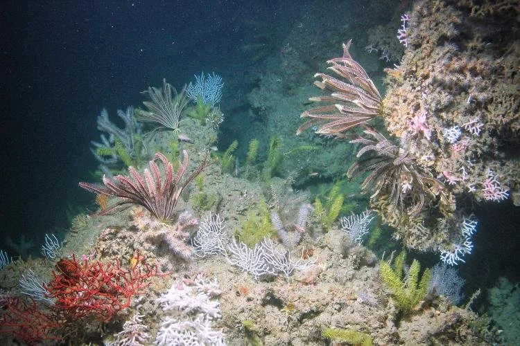
Mesophotic corals and crinoids on Bright Bank, near the Flower Garden Banks National Marine Sanctuary. Credit: Marine Applied Research and Exploration, NOAA
365 days of continuous time-series video data
Successful operation at depths greater than 1,500 meters
A structured visual dataset supporting long-term ecological analysis
As Carrick puts it, “It’s fairly unprecedented to have actual video footage of a habitat over this span of time.” For projects where long-term deployment, deep-sea reliability, and usable scientific imagery all matter, this work shows what is possible when the right imaging system is built into the broader monitoring approach.
The footage collected across sites from Henderson Ridge to the West Florida Escarpment is providing scientists with new insight into environmental variability and habitat response to restoration, protection, and management efforts across the Gulf of America.
What’s Next: Expanding Deployment Flexibility
As the project continues, the URI team is also looking at new ways to use the same camera systems during deployment. In addition to long-term autonomous monitoring with onboard recording, future workflows may benefit from real-time topside viewing during lander placement and setup.
This added flexibility is valuable for deep-sea operations. Autonomous deployments often rely on internal storage, where footage is saved onboard for later retrieval. Deployment and live operations, however, can benefit from real-time topside transfer for immediate viewing and decision-making. Because the same Rayfin Autonomous Timelapse Camera System can support both onboard recording and real-time topside transfer, teams have more options depending on the mission.
For projects like this one, that flexibility could support both precise deployment and long-term observation without requiring a separate imaging setup.
Conclusion: A Stronger Approach to Long-Term Deep-Sea Monitoring
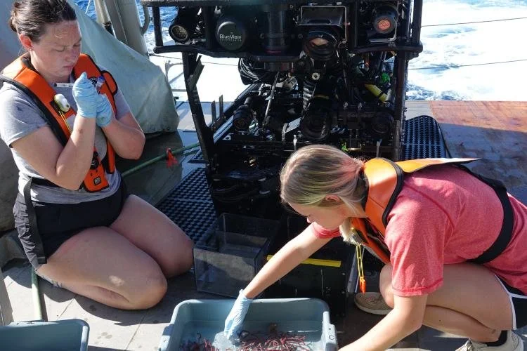
Aquarists retrieve coral samples collected from a mesophotic reef by a remotely operated vehicle. This work took place in July 2022 during a cruise to study coral spawning in and around Flower Garden Banks National Marine Sanctuary. Credit: Kelly Martin/NOAA
For the URI team, long-term monitoring in the deep sea required more than a camera that could survive at depth. It required a system capable of delivering reliable image quality, operating autonomously for extended periods, and supporting the kind of time-series data needed for habitat assessment.
By integrating SubC Imaging cameras into its custom lander systems, the team was able to collect visual data from depths greater than 1,500 meters over the course of a full year. Combined with environmental sensor data, that footage is helping scientists build a clearer picture of how deep benthic communities function in the Gulf of America.
Funding for this work was provided by the Mesophotic and Deep Benthic Communities Habitat Assessment and Evaluation Project, which was selected by the Open Ocean Trustee Implementation Group to restore natural resources injured by the 2010 Deepwater Horizon oil spill. Any use of trade, firm, or product names is for descriptive purposes only and does not imply endorsement by the U.S. Government.